Maine is known for its scenic beauty and vibrant tourist attractions, but the state also has a rich history of abandoned places that offer a glimpse into the past. From forgotten mansions to eerie old forts, there are many fascinating places to explore in Maine. In this article, we will take a look at the best abandoned places in Maine that are worth exploring.
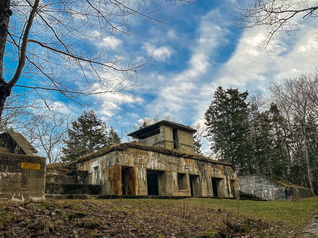
1. Battery Steele

Address: Florida Avenue, Peaks Island, Maine
Location Directions: HERE
Battery Steele is a historic coastal gun battery on Peaks Island in Maine. Peaks Island is uniquely situated in Casco Bay and is just about a mile and a half off the shores of Portland, Maine. This location made it the perfect place to establish a fort to strengthen the Harbor Defenses of Portland. The Peaks Island Military Reservation was established in 1906 during the Endicott Period. During WW1, the reservation was not very large and contained just a pair of searchlights and a fire control station.
It was during World War 2 that Battery Steele was completed. Battery Steele was built in 1942 and was equipped with two 16-inch MarkII-M1 guns mounted on one M4 and one M5 Casemated Barbette Carriages. Each gun emplacement was covered by a massive concrete casemate that hung over it. The whole battery was also covered with earth to blend into the surroundings. After WW2 ended, the battery was abandoned and has sat abandoned ever since. It was listed on the National Register of Historic Places in 2005 and is open to the public for exploring!
Learn more about the abandoned Battery Steele
2. Goddard Mansion


Address: 1000 Shore Road, Cape Elizabeth, Maine
Location Directions: HERE
The Goddard Mansion is a fascinating abandoned mansion in Cape Elizabeth, Maine in the present-day Fort Williams Park. It was originally built during the 1800s by John Goddard who was a wealthy businessman who made his fortune in the local Orono lumber industry. Goddard hired Charles A. Alexander, a renowned architect from Maine, to create an Italianate house out of local stone. The Goddard family moved into their opulent new mansion in 1858. The home’s hilltop establishment provided amazing views of Casco Bay and the always dramatic Portland Head Light.
The mansion remained in the Goddard family for many decades until it was sold to Judge Joseph W. Symonds of the Maine Supreme Court in 1898. During the Endicott Period of coast artillery fortifications, Fort Willaims was established adjacent to the mansion. The government eventually acquired the mansion and its land to expand the fort. The mansion itself served as housing for married noncommissioned officers and their families. In the basement of the Goddard mansion was the officers’ club. Fort Williams remained operational through both World Wars and even the Cold War. It was not until 1962 that the fort was abandoned.
The town of Cape Elizabeth acquired the fort property after it was decommissioned. Many structures were boarded up or destroyed as the town established a park on the old fort grounds. The Goddard Mansion was boarded up, but became a popular place among vandals. Several small fires at the mansion made it hazardous. The town was unsure whether to restore the home or tear it down. They decided on a unique compromise. In 1981, the town asked the Cape Elizabeth Fire Department to carry out a series of controlled burns inside to remove the roof and all timber rather than fixing it or entirely destroying it. To avoid any danger to the public, the basement was filled in and only the stone shell and core were left.
Learn more about the Goddard Mansion
3. Fort Gorges

Address: Hog Island Ledge, Portland, Maine
Location Directions: HERE
Fort Gorges is an amazing abandoned fort located on Hog Island Ledge in Casco Bay in Maine. The fort is located right near the entrance to Portland’s Harbor and it was built as part of the third system of forts in the United States. It was constructed to support existing forts, including Fort Preble in South Portland and Fort Scammel, which was built on nearby House Island in 1808.
Fort Gorges was constructed between 1858 and 1864. It was named after Maine’s colonial proprietor, Sir Ferdinando Gorges. Surprisingly, no battles were ever fought at the fort, nor were any troops ever stationed there. Military technology advancements, such as ironclad ships and long-range guns, rendered the fort obsolete before it could be used.
The city of Portland purchased it in 1960, and it was added to the National Register of Historic Places in 1973. It is now open to the public as a park and can only be reached by private boat/watercraft or water taxi. It is recommended that visitors bring a flashlight with them when entering the powder magazines. The Friends of Fort Gorges look after the fort and recently raised $500,000 for critical repairs in 2019. The fort can be viewed from the mainland from the Eastern Promenade of Portland and Bug Light Park.
Learn more about the historic and abandoned Fort Gorges
4. Eagle Lake & West Branch Locomotives (Ghost Trains)

Address: Narrow Pond Road, Northwest Piscataquis, Maine
Location Directions: HERE
The Eagle Lake & West Branch Locomotives are two abandoned trains located in the Maine North Woods. They were originally used to carry pulpwood along the Eagle Lake and West Branch Railroad which operated from 1927 to 1933. During its operations, the trains allowed the Great Northern Paper Company to produce almost one-fifth of the country’s yearly paper production by transferring 6,500 cords of pulpwood per week. The railroad garnered the nickname the “Pulpwood Express.”
The trains and paper operations were abandoned in 1933 when the Great Depression hit and decimated the industry. These two locomotives were put into a shed while the other two locomotives operating along the railroad were transferred for usage elsewhere. Since the operations never re-opened, the trains were left abandoned in the shed. Eventually, the shed burned down in the 1960s and the trains have been sitting out in the middle of the North Woods for many decades. They are truly some of the most fascinating sites in the state of Maine.
On May 7, 1979, the locomotives were listed on the National Register of Historic Places as part of the Tramway Historic District. This is a major honor and it ensures that the locomotives will be cared for and open to the public for generations to come. Today, the trains can be found in the town of Eagle Lake Township in the North Maine Woods. They are located in the Allagash Wilderness Waterway which is a state park administered by the Maine Bureau of Parks and Recreation. To reach the trains, it will take a lot of time and some good vehicles. The trains are located along a super remote trail that is about two and a half hour drive from the nearest city. You will find no shops, gas stations, or homes anywhere nearby. That said, if you are up for the adventure, you will be rewarded!
Learn more about the mysterious Maine Ghost Trains
5. Fort Popham


Address: 219 Popham Road, Phippsburg, Maine
Location Directions: HERE
Fort Popham is an amazing historic and abandoned coastal defense fort located on the shores of Phippsburg, Maine. The fort’s location was deemed strategically important during the Civil War, as it provided a critical vantage point for the defense of the Maine coast, Kennebec River, and shipping lanes of Penobscot Bay. Construction of the fort began in 1861 but was not completed until 1869. The fort was equipped with state-of-the-art armaments, including heavy artillery guns, and was staffed by a detachment of U.S. Army soldiers.
Throughout its history, Fort Popham has served as a center of military activity, a hub of commerce, and a symbol of the United States’ commitment to coastal defense. Today, the fort stands as a testament to this rich cultural heritage and is a popular tourist destination, attracting visitors from all over the world. It received the district honor of being listed on the National Register of Historic Places on October 1, 1969.
Learn more about the historic Fort Popham
6. Evergreen Ski Resort

Address: Mountain Road, Stoneham, Maine
Location Directions: HERE
Deep in the woods of Stoneham, Maine, explorers will find the now-abandoned Evergreen Ski Resort.
The Evergreen Ski Resort was established at the base of Adams Mountain which stands 1,700 feet tall in the White Mountain National Forest. Its first season was during the winter of 1972-1973, but it took a lot for it to open. The idea of a ski mountain in the town of Stoneham was first hypothesized during the 1960s when local residents thought a ski mountain could help boost the local economy. The towns of Stoneham, Sweden, and Lovell came together in 1962 to discuss the possibility of a ski resort. Over the next several years, many discussions were held about the feasibility of the ski project, what other amenities would be included, and also how it would all be funded.
By 1970, a lot had come together regarding the resort and groundbreaking occurred. At this time, there were aspirations to create an amazing recreational area complete with a ski lodge, tennis courts, a golf course, a swimming pool, snowmaking machines, two chair lifts, a T-Bar, and lights for night skiing. The projected cost of the project grew over the years from under a million dollars to approximately $40 million in 1970. Many millions would come from bond sales with some being backed by the Maine Recreation Authority. On July 2, 1970, a grand groundbreaking ceremony was held for the official groundbreaking of the Evergreen Ski Resort. The ceremony was attended by Governor Kenneth Curtis and he talked about how significant and beneficial the project was going to be.
Some of the first structures to be built were the lodge and chair lifts. Construction was eventually halted in December of 1970 due to financing issues. Some of the government-backed bonds were reportedly withdrawn along with some new requirements. This led to the mountain resort project’s new owner. Robert Friedlander took a look at the site in 1971 and came up with a strategy to seize control of it and open it to the public. Friedlander, a Pleasant Mountain skier, was from a Boston real estate family. Friedlander established the Exeter North Corporation as the 1972–1973 ski season drew near to rent the ski area from the Development Corporation for Evergreen Valley. Friedlander also created blueprints for a $500,000 motel and condominium structure to be built next to the ski slope. Early in December 1972, the slopes were blanketed in snow, and excitement was growing for a deal. As negotiations proceeded, furniture was ultimately placed inside the lodge and the lifts were turned on. On December 16, 1972, the ski facility finally opened for business after many years of anticipation.
In January 1973, the final details of the lease were worked out, officially handing control to Exeter North. An opening ceremony was planned as the season went on. Local newspapers ran advertisements promoting the news, making locals and tourists excited. On the afternoon of March 3, 1973, the ski area was dedicated with Governor Kenneth Curtis present. A new 160-bed inn also went under construction following the ceremony and this was another thing to celebrate. After the ceremony, there was an ice performance, night skiing, a dinner buffet that was sold out, and a torchlight parade.
The resort included three cocktail lounges, a base lodge for $1 million, three double chairlifts serving 50 acres of terrain, night illumination on the lower mountain, and snowmaking. In addition to skiing, the resort had a marina on Kezar Lake, a Robert Trent Jones-designed 9-hole golf course that had only been partially completed (an additional 9 holes were intended but were never built), swimming pools, and tennis courts. Equestrian sports, heated outdoor swimming pools, bubble-enclosed tennis courts, and snowmobiling were available as wintertime diversions. There were plans to build condominiums on up to 1,200 acres.
The new inn was opened in the summer of 1973, but things started going downhill from there. During that winter (1973-1974), New England had one of its worst snowfall totals on record and Evergreen’s snow-making machines were broken. This was a major disaster for the resort’s reputation and economics. During the next winter, the resort sold insurance on all-season tickets in case the snowfall was too little to ski. The season did not turn out to be very successful. All these unfortunate events led to the resort closing down in the summer of 1975.
The resort was then sold to an attorney from Norway, Maine named Rupert Aldrich. He operated the resort for a few years but struggled with proper snow-making. The mountain was closed during the 1979-1980 season and eventually, the business fell into foreclosure once again in 1981. The Finance Authority of Maine (FAME) then purchased the property for $500,000 at a public auction on May 25, 1983.
Several bidders attempted to purchase the property from FAME. It was eventually sold to Robert Bahre on May 12, 1986, for $1.35 million. Bahre was potentially going to create a casino on the site, but this never happened. He did not take care of the property and did not attempt to reopen the skiing operations. In the early 1990s, the US Forest Service ordered the lifts to be removed. On December 4, 2017, the resort was sold once again and it is unclear what will happen to it in the future.
7. Fort Baldwin
Address: 46 Fort Baldwin Rd, Phippsburg, Maine
Location Directions: HERE
Fort Baldwin is a historic site in Phippsburg, Maine that consists of several abandoned coastal defense buildings. Fort Baldwin was established in 1905 during the Endicott Period of coastal fortifications. From 1905 to 1912, three coastal gun batteries were built at the fort to strengthen the defenses of the Kennebec River and the coast of Maine. A concrete fire tower was added to the fort during WW2. The following are amazing abandoned structures at Fort Baldwin to explore today, they are each only a few hundred feet from each other.
Battery Cogan at Fort Baldwin
Battery Cogan was built in 1908 and was named after Patrick Cogan who was an officer in the Continental Army during the Revolution. Battery Cogan was equipped with two 3-inch M1903 guns mounted on M1903 Pedestal mounts. It was strategically built on Sabino Hill in Phippsburg and has sweeping views of the Kennebec River and the Atlantic Ocean.
During World War 1 (from 1914 to 1918) the battery was staffed. It is unknown how many people worked at Battery Cogan, but there were about one hundred artillerists stationed throughout Fort Baldwin during WW1. Thankfully, the battery never had to fire a single shot. After World War 2 ended, Battery Cogan was deactivated and the guns and mounts were transported to Fort Preble in Portland, Maine. Once shut down, the structure was sold to the state of Maine in July of 1924 and then abandoned.
Learn more about the abandoned Battery Cogan
Battery Hardman at Fort Baldwin

Battery Hardman was built in 1908 and was named after John Hardman who was an officer in the Continental Army during the Revolution. Battery Hardman was equipped with one 6-inch M1905 gun mounted on an M1903 Disappearing carriage. During the first World War, from 1914 to 1917, the battery was staffed. Interestingly, the 6-inch M1905 gun was sent to France to help aid in the final year of the war. The gun arrived in 1918 and the war ended soon after. Following the war, the gun was transported back to Maine and was put into storage at an arsenal. Officially, the battery was abandoned in 1917 after its gun was removed. It was then transferred to the state of Maine in July 1924.
Learn more about the historic Battery Hardman
Battery Hawley at Fort Baldwin

Battery Hawley is the third and final gun battery at Fort Baldwin and it is located the furthest up Sabino Hill in Phippsburg, Maine. Construction of Battery Hawley began in 1905 and it was completed in 1908. The structure was named after Joseph Hawley. Hawley was an officer in the Union Army during the Civil War. To defend the Kennebec River and the coast of Maine, Battery Hawley was equipped with two 6-inch M1900 guns placed on M1900 Pedestal mounts.
During the first World War, from 1914 to 1917, the battery was staffed. Thankfully, the battery never had to fire a single round. Interestingly, the 6-inch M1900 guns were scheduled to be sent overseas in 1917 to help Europe allies during the war. Battery Hawley’s guns were removed and placed on a railcar but ultimately were not needed. The war ended in 1918 and the guns were returned to the battery and re-mounted. After tensions around the world had died down, the battery was no longer deemed necessary by the government. It was officially deactivated in 1924 and ownership was transferred to the state of Maine.
Learn more about the abandoned Battery Hawley
WW2 Fire Control Tower at Fort Baldwin

After many years of being abandoned, the fort once again was active during World War II. Immediately after the war began, the government sought to secure the coast of Maine and the important Kennebec River. Men were quickly stationed at Fort Baldwin and nearby Fort Popham. In 1942, the fire control tower was constructed on the top of Sabino Hill on the grounds of Fort Baldwin. The tower is a square concrete tower that stands five stories tall. From the top of the tower, lookouts could see for miles in all directions and detect any enemy threats quickly. Additionally, during World War 2, mobile guns were placed on the hill in case of any invasion. Following the war ending in 1945, the fire control tower was abandoned and the mobile guns were removed. The land was once again transferred back to the state of Maine.
Learn more about the Fort Baldwin Fire Control Tower
8. Dyer Brook General Store

Address: 815 Dyer Brook Rd, Dyer Brook, Maine
Location Directions: HERE
Time travel may not be possible, but if you are looking to step back in time for a few moments, visiting Dyer Brook General Store is sure to help you do that. This general store was first opened in 1947 and it became a staple of residents living in Dyer Brook and the surrounding towns. It was also popular among visitors passing through the area considering Dyer Brook Road used to be a heavily trafficked road before Interstate 95 was built. It was a well-stocked store that offered groceries, medications, clothing, and seasonal items like toboggans in the winter and lounge chairs in the summer. Outside the store, there was gas available.
Over the years, it became a true community gathering place. It was founded and operated by Laurel “Jiggs” McNelly and his brother. Jiggs was a true Mainer and a lover of his community. Many residents who shopped at Dyer Brook General Store have praised Jiggs for his hard work and also for his willingness to extend credit to locals so they could purchase necessary products and pay later.
Sadly, traffic began to lessen at the general store when Interstate 95 was constructed just a mile west of the store. The highway was constructed in 1956 and this led to the traffic driving past the store to drop significantly. In 1969, the Dyer Brook General Store was closed down and the brother decided to open up a store closer to the interstate. This new store was named Whitey’s Market and it is still operating today in Oakfield, Maine along Oakfield Smyrna Road.
Today, visiting Dyer Brook General Store is like walking back in time. The store has hardly been touched since it was abandoned in 1969. There are still old political posters inside and old Pepsi-Cola signs on the outside. The store sign is also still on the outside of the building, but it is very deteriorated. The store is still owned by the same family and it is private property. If you visit, be sure to take photos from the roadside only.
9. Katahdin Iron Works State Historic Site

Address: Katahdin Iron Works Road, Brownville, Maine
Location Directions: HERE
Now, the Katahdin Iron Works’ sole remaining structures are the skeletal remains of a blast furnace and a charcoal kiln. These buildings once hummed with activity as the sole iron works operation in Maine during the nineteenth century. Here, the blast furnace fires burned continuously for as long as a year at a time, illuminating the nighttime sky. This charcoal furnace and numerous others emitted smoke. Ore, pig iron, or timber was continuously being carried by mules, oxen, or horses pulling rattling wagons.
These sights and noises must have sounded strange amid the wildness of Maine. Yet, the iron works industry was brought to this location by the wilderness, with its accessible access to iron ore, fuel wood, and water power.
Between 1843 and 1890, a total of around 25 years, Katahdin Iron Works was in operation here. Despite being remote, it was tightly connected to foreign markets and improvements in the iron industry’s technology. For instance, its beginnings coincided with a rise in demand for iron agriculture equipment, machinery, and railroad car wheels. While massive mills in Pennsylvania ushered in the nation’s new age of steel, the ironworks ultimately failed.
After the iron works company closed down, the site was abandoned and many of the local townspeople moved because they lost their jobs at Katahdin Iron Works. The land containing the blast furnace and the charcoal kiln was sold to a chemicals company in 1952, but these structures and the land around them were donated to the State of Maine in 1968. Katahdin Iron Works has been operating as a historic site since 1965 and it is managed by the Maine Bureau of Parks and Lands. The location was listed on the National Register of Historic Places on December 23, 1969.
10. Battery Keyes

Address: 1000 Shore Road, Cape Elizabeth, Maine
Location Directions: HERE
Battery Keyes is an abandoned coastal gun battery that can be found on Fort Williams in Cape Elizabeth, Maine. Construction on Battery Keyes began in 1903 and was completed in 1905. It was officially transferred to the Coast Artillery for use on April 27, 1906. The battery stood two stories tall. There were two magazines located on the first level and the second level was home to the two 3-inch M1902MI guns mounted on M1902MI Pedestal carriages. No shell hoist was installed at this battery which meant that shells would have to be transported to the guns from the magazines by hand. Additionally, there was a fire control station situated in the middle of the battery and a range finder station just to the east.
During World War 2, Battery Keyes remained a part of the Harbor Defenses of Portland. Its guns were on alert for any foreign enemies. When the war ended in 1945, the battery was declared surplus by the government. Orders for the carriages and guns to be salvaged were received on October 18, 1945.
Today, Battery Keyes can be found in Fort Williams State Park in Cape Elizabeth, Maine. The battery can be found just west of Portland Head Lighthouse. There are no original weapons or mounts at the battery, but the concrete core is in pretty good shape. Fortunately, many of the doors leading into the first level rooms of the battery are open. Additionally, the range finder station is completely open. It is fun to glance inside this obscure war structure.
Learn more about the decaying Battery Keyes
11. Cape Elizabeth MR Fire Control Tower

Address: 7 Tower Dr, Cape Elizabeth, Maine
Location Directions: HERE
The Cape Elizabeth Military Reservation was a World War 2 military reservation that operated from 1942 to 1946. The government began acquiring plots of land as World War 2 started to increase the Defenses of Portland, Maine. One of these plots was a roughly 40 acres site located at the southern end of Cape Elizabeth. On this land, Battery 201 was built and a fire control tower was built a few hundred yards behind the coastal gun battery.
This fire control tower is officially known as Cape Elizabeth Military Reservation Fire Control Tower at Site 1B. The control tower is circular and was built to resemble a lighthouse standing about 5 stories tall. There are three levels of observation posts at the top of the tower. This control tower is unique considering how abandoned and public it is. The two other observation towers that were built at the reservation are currently owned by private owners, painted, and decorated to look like lighthouses.
Learn more about the abandoned Cape Elizabeth Fire Control Tower
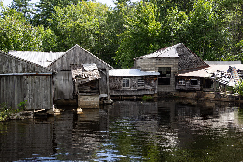
12. Striar Textile Mill (Ayers Island Mill)

Address: Ayers Island, Orono, Maine
Location Directions: HERE
In Penobscot County, Maine, close to the town of Orono, there is an island called Ayers Island in the Penobscot River. It was given that name in honor of Joshua Ayers, who built a sawmill on the island starting in around 1774 and was one of Orono’s first inhabitants. The island itself is about 62 acres.
The huge mill complex that currently can be found on the island was established around 1838. It was designed to be a sawmill that processed timber that had been felled in inland Maine and then floated down the Stillwater River. It produced pulp and paper from the wood. The mill complex has undergone numerous alterations and extensions since 1838. The majority of the present-day structures on the island were constructed around 1907 when the largest additions were made. As the mill was transformed from a sawmill to a textile mill in the middle of the 1940s, more alterations were performed. The textile Mill was known as the Striar Textile Mill. When the owners filed for bankruptcy in 1996, the mill was finally shut down. Today, the mill is abandoned and popular among explorers who love Urbex.
13. Casco Castle Tower

Address: 15 Castle Road, Freeport, Maine
Location Directions: HERE
The Casco Castle Tower is a fascinating structure in Freeport, Maine that has a wild history. The tower was built in 1903 and was part of the Casco Castle resort. Amos F. Gerald of Fairfield, Maine was the man who had the grand vision for the castle-looking resort. He was so passionate about establishing this resort in Freeport because he was the owner of the Portland and Brunswick Street Railway which had just opened a new route. This route into Freeport would allow people to arrive at the resort via trolley cars. Ultimately, the trolley car business would benefit from the resort and the resort business would benefit from the trolley cars.
To build the grand castle, Gerald hired William R. Miller and his architecture firm. When finished the hotel building had 5 floors and a unique freestanding stone tower connected by a bridge. Rooms in the hotel and the tower boasted sweeping views of Casco Bay. Also, there was a restaurant inside the hotel, and on the grounds, visitors could enjoy a picnic area, baseball field, and small zoo.
The Casco Castle had a solid few years in operation, but then trouble occurred. As the automobile began to become the preferred mode of transport in the country, trolley car usage went down. This meant people had more options on where to travel to and many stopped showing up to Casco Castle. Additionally, Gerald’s Portland and Brunswick Railway business was forced to foreclose in 1911. Eventually, the resort closed in 1914 after eleven years in operation. A new owner attempted to re-open the resort, but a major fire broke out and destroyed all of the main hotel buildings, leaving just the Casco Castle Tower standing. Learn more about this abandoned location at goxplr.com/places/casco-castle-tower
14. Loring Air Force Base
Address: Energy Road, Limestone, Maine
Location Directions: HERE
The Loring Air Force Base near Limestone and Caribou in Aroostook County is one of the coolest abandoned locations in the state of Maine. The base was established in 1947 by the US Army Corps of Engineering because of its unique location. It was the closest point in the continental U.S. to Europe, providing high strategic value during the Cold War. As part of the Strategic Air Command (SAC) (1947–1992) and the ensuing Air Combat Command (ACC), Loring served as a heavy bomber, aerial refueling, and interception base for military aircraft, equipment, and supplies.
It was built to hold more than 100 B-36 Peacemaker strategic bombers. Budgetary limitations led to just a partial implementation of this strategy. Later, Loring grew to become one of SAC’s biggest air bases. The B-52 Stratofortress was based at Loring after the B-36 was phased out, initially with D models and then with B-52Gs. The base also served as the home for the Boeing KC-97 Stratofreighter for a while before the KC-135A Stratotanker took its place.
From 1954 to 1958, one of Loring’s important secondary tasks included acting as the 45th Air Division’s administrative center. With the exception of a brief period in its early years, the 42d Bombardment Wing served as the host wing at Loring. When the Massachusetts Air National Guard’s 101st Fighter Squadron sent a detachment to Loring in the 1980s, active military forces were the majority of the residents of Loring. The facility served as an essential stopover because it was the one in the US that was closest to Europe. Loring AFB was shut down in September 1994 as proposed by the Base Realignment and Closure Commission of 1991. Afterward, the Loring Trade Center and an International Airport were opened.
Today, visitors can check out a few of the abandoned buildings at the air force base. These are great for urban explorers. Some key structures include a massive hangar, multiple barracks, planning buildings, a water tower, and more.
15. Fort McClary Caponier

Address: Pepperrell Rd (ME-103), Kittery Point, Maine
Location Directions: HERE
The Fort McClary Caponier is a fascinating abandoned and historical site in Kittery, Maine.
The caponier can be found along the seawall of Fort McClary. This fort was officially established in 1808 as part of the second system of US fortifications. It was strategically positioned at the mouth of the Piscataqua River which allowed the harbor of Portsmouth to be protected. The harbor of Portsmouth harbor was home to the valuable Portsmouth Naval Shipyard which required extra protection from any potential invasions.
Over the years, the fort was expanded upon. Although the fort saw hardly any action during the Civil War, major additions and renovations began in 1863. This period of building was part of the third system of US fortifications. New seawalls were completed during this period and the caponier was added too. The caponier featured over a dozen rifle ports that were nearly completely invisible from the water. This caponier was a key defense feature to Fort McClary.
The caponier remains today and it is in pretty good shape. Visitors are welcome to go inside Fort McClary Caponier when the gates are open. It is a fascinating place to walk around in and imagine how things were like centuries ago.
Learn more about the Fort McClary Caponier
16. Battery Chapin

Address: Pocahontas Road, Kittery Point, Maine
Location Directions: HERE
Battery Chapin is a stunning and abandoned reinforced concrete coastal gun battery on Fort Foster in Kittery, Maine. During the Endicott Period of coastal fortifications, the government noticed that the Harbor Defenses of Portsmouth needed strengthening. Portsmouth was an important harbor to protect due to the Portsmouth Naval Shipyard and the entrance to the Piscataqua River. One of the defense systems built to increase capabilities was Battery Chapin.
Construction on Battery Chapin was completed in 1904. On December 31, 1904, the battery was transferred to the Coast Artillery for use. It was equipped with two 3-inch M1902MI guns mounted on M1902 Pedestal carriages. Two stories made up the structure. The lower level was the magazine where shells and powder were stored. The upper level was where the guns were mounted and a small lookout post was built. No shell hoists were installed, so men stationed at the battery had to manually move all ammo.
Battery Chapin remained active during both World War 1 and World War 2. After WW2, the battery was decommissioned. The guns and mounts were removed in 1945 and then the battery was abandoned. Over the years, the battery and its surrounding land have become a public park named Fort Foster Park. Visitors are welcome to admire the old Battery Chapin along with Battery Bohlen, Battery 205, and the Fort Foster Fire Control Tower.
Learn more about Battery Chapin
17. Swan Island Ghost Town

Address: 7 Swan Island Landing, Richmond, Maine
Location Directions: HERE
The vast natural beauty of Maine, which is abundant in flora and animals and amazing forests, is perhaps what most people picture when they think of the state. Yes, that is logical. But keep in mind that Maine has a long history and a wealth of historical tales. It is a state that dates back to the founding of the country, and it undoubtedly has some dark secrets. The state’s history is very secretive.
One of the most intriguing of these tales is one we don’t hear very frequently, yet it conceals one of Maine’s most amazing abandoned locations. Swan Island, which is in the Kennebec River, has been uninhabited for a very long time. It is a quintessential ghost town. There’s a real treat in store for you if you’re curious about what Maine looks like after it’s been abandoned to nature. The eeriest abandoned town in Maine has been located, it’s Swan Island!
Five abandoned homes built in the 1700s can be found on ghost island. Both early settlers and Native American tribes lived on the island. It served as a launching pad for historical luminaries like Benedict Arnold and Aaron Burr. Some claim that river contamination caused the island to be abandoned. Families had to relocate since the island’s businesses were forced to close. According to the official version of events, the state of Maine gradually started to acquire small parcels of land.
Today, the island is owned by the state and it welcomes visitors from May through October. Visitors must kayak or canoe to the island or take a boat. There are 5 old homes to check out, as mentioned before. There is also an old cemetery too! If you are looking to stay on the island overnight, there are a couple of lean-tos available.
18. US Customs Building

Address: 16 Border Lane, Houlton, Maine
Location Directions: HERE
The abandoned US Customs Building in Houlton, Maine is a very interesting place. It can be found right on the border of the United States and Canada. The customs building was built in the early years of the 20th century, although the exact date is unknown. For years, this customs building was used to monitor immigration.
This old customs building was constructed along Route 2, which used to go straight into Canada. On October 25, 1985, a new customs station was opened just a few hundred feet north along the new Interstate 95. This rendered the prior US Customs Building unnecessary and the government abandoned it. The road leading into Canada was destroyed to avoid anyone from driving across from the old station into another country illegally.
Since 1985, the abandoned US Customs Building has been slowly reclaimed by nature. Some vandals got to the building after it was abandoned, but eventually, the town decided to board it up to keep people out. Many locals want the building demolished because it is an eyesore. This is a little complicated because the cost would be rather high considering the asbestos inside which would need to be removed carefully. It is unknown what the future will be for this old government building. People can drive right up the present-day Border Lane to check it out!
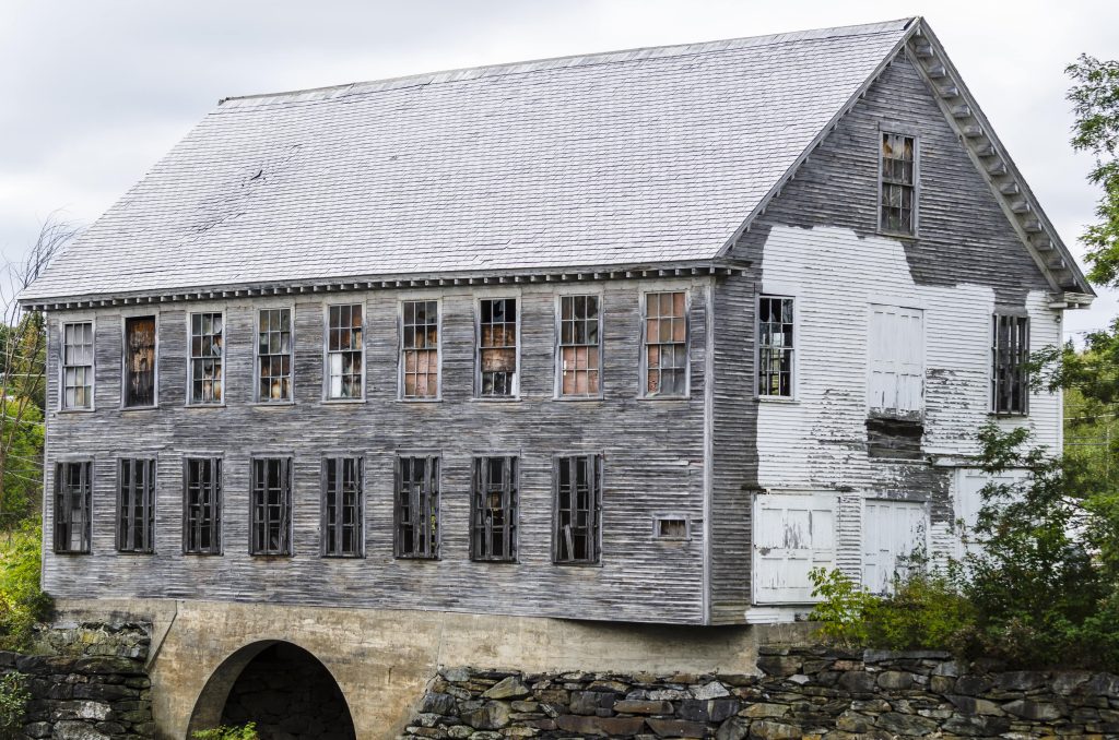
19. Moulton Mill
Address: Bond Spring Road, Newfield, Maine
Location Directions: HERE
This Moulton Mill is a historic and abandoned structure located in Newfield, Maine. The mill was first known as Adam’s Sawmill and it was established way back in 1790. It was later purchased by Charles Moulton in 1882 and he continued the sawmill operations. Generations of the Moulton family ran the mill until 1986 when the town of Newfield noticed sawdust from the mill was getting into the river that it was powered by. This sawdust problem was unavoidable and this led to the Moulton family shutting down the mill.
The mill was sold to Anthony Tedeschi from the neighboring town of Limerick, Maine in 1995. Tedeschi saw that the mill was abandoned by the Moultons and he wanted to preserve its history and turn the mill into a museum. Sadly, Tedeschi’s vision was unattainable because the mill was in pretty rough shape with tons of rotting wood throughout. It was too costly for Tedeschi to preserve the mill so he abandoned it. Since being vacant, the mill has become popular among Maine Urban Explorers. Much of the valuables inside the mill were also stolen by thieves who broke in. Nowadays, there are a lot of no-trespassing signs, so things have settled down. Fortunately, the mill can be viewed right from the roadside.
20. Kezar Falls Woolen Mill
Address: Federal Road, Parsonsfield, Maine
Location Directions: HERE
The Kezar Falls Woolen Mill is a large abandoned old mill in the village of Kezar Falls within the town of Parsonsfield. The mill was built in 1880 and was added on to over the years, with a major wing addition in 1929. It was a full processing mill of woolen goods and for over a century, the mill would spin, dye, weave, and then create clothing. The mill was a major employer of Parsonsfield and its products helped the economics of the town significantly. Unfortunately, during the 1990s, the mill started facing competition, especially from overseas clothing producers. The Kezar Falls Woolen Mill could not offer lower prices than its off-shore competition and ultimately this led to its collapse.
The mill has sat abandoned since the 1990s. A few Maine Urban Explorers have ventured to the mill to check out what remains at the mill. One blog post from Abandoned But Not Forgotten showcases what can still be found inside the mill from scales, gears, desks, boilers, and more!
21. B-52 Crash Site Memorial

Address: GHH8+54, Beaver Cove, Maine
Location Directions: HERE
Visitors visiting the recreational haven of Moosehead Lake might be unaware that a massive US Air Force Boeing B-52C Stratofortress crashed eight miles into the forests on the southern side of Elephant Mountain. Many acres of forest have been covered in airplane wreckage and rubbish. You are free to explore this living tribute to a tragedy from the Cold War.
Nine crew members of the subsonic, jet-powered strategic bomber took off from Westover Air Force Base in Chicopee, Massachusetts on what was supposed to be a normal training trip on a bitterly cold January afternoon in 1963. However, the aircraft encountered turbulence due to winds coming off western Maine’s mountains. A structural collapse was caused by those powerful winds, and a piece of the bomber’s tail was severed. The pilot gave the order to leave the B-52C after failing to level it.
On the upper flight deck, only three crew members had the time and resources to eject. Maj. Robert J. Morrison, the bomber’s co-pilot, successfully parachuted off the plane but was killed when he collided with a tree. The only person to have ever survived an ejection from an airplane without the parachute opening was navigator Capt. Gerald J. Adler. He broke three ribs and his head as he landed in his ejection seat upright on the snow. Lt. Col. Dante E. Bulli, the pilot, was the second person to survive. He managed to pass the night hanging from a tree 30 feet above the ground in minus-29-degree weather. In total, 7 people died that night and 2 survived.
22. Fort Preble

Address: Bunker Lane, South Portland, Maine
Location Directions: HERE
Fort Preble is a fascinating Maine fort located in South Portland, just steps from Spring Point Ledge Lighthouse. It was built in 1808 and gradually expanded until 1906. From the War of 1812 to World War II, the fort remained operational.
The first structure at Fort Preble was a unique gun emplacement. It was built in a unique star shape and featured 14 guns. The fort was first used to stave off an attack by a foreign force in the event that the United States was regarded as a belligerent in the ongoing battle between Great Britain and Napoleonic France. The fort worked to secure the coast along with Fort Scammell on adjacent House Island. To enforce the Embargo Act against embargo-breaking ships, Henry Dearborn (secretary of war) directed a company of the Regiment of Light Artillery under Captain Joseph Chandler to occupy the fort in October 1808. By forbidding exports to Britain and France, the embargo sought to penalize them for their activities against US vessels. This law was quite unpopular and cut off a significant portion of New England’s income. When President James Madison assumed office in March 1809, the embargo was finally abolished; nonetheless, the situation ultimately resulted in the War of 1812.
The fort remained active during the War of 1812 and the Civil War. It was during the 20th century that major changes came to the fort. When the Endicott Period of coastal gun fortifications began in 1896, Fort Preble was a key location to help boost the security of Portland, Maine. Many coastal gun batteries were constructed in the area along with two at Fort Preble. Much of the original star fort was destroyed to build Battery Kearny, Chase, and Rivardi. These coastal gun batteries were operational during World War 1 and 2. Eventually, the fort was decommissioned in 1950 after WW2 because the gun batteries were now outdated. The land around the fort was sold to the State of Maine in 1952. It eventually was developed to become the campus of the Southern Maine Vocational Technical Institute which was renamed later to Southern Maine Community College. A small public park was established at Fort Preble which allows visitors to enjoy all the old structures still standing.
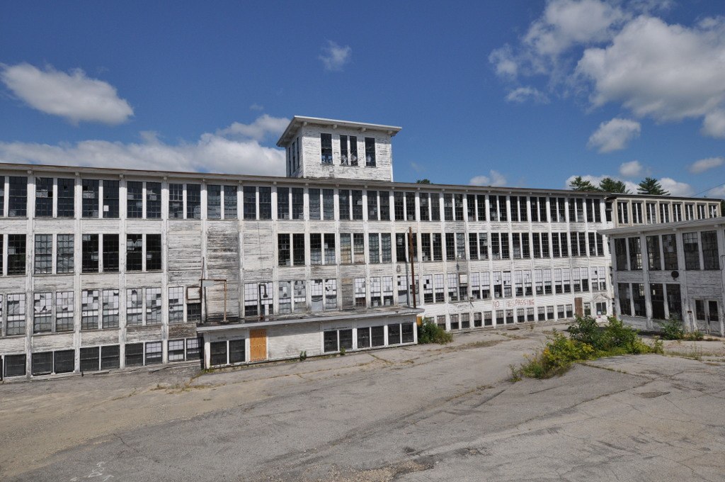
23. Milo Textile Company Mill
Address: Riverside Street, Milo, Maine
Location Directions: HERE
The Milo Textile Company was once a thriving textile mill that now sits abandoned. The mill was built in 1879 along the Sebec River in Milo, Maine by the Boston Excelsior Company. The company manufacturer excelsior at the mill for several decades until eventually selling the mill. The new buyer was the textile company, known as the Milo Textile Company. This textile company transformed the old excelsior mill into a textile mill and began producing textiles in June of 1922. The company produced high-grade machine yarns and employed 70 people who were all from the town.
The Maine textile industry eventually was crippled by competition from overseas. This led to the closure of the Milo Textile Company Mill. The mill was eventually sold and it was most recently owned by Leon A. Cousins of East Millinocket, Maine. Cousins passed away in 2013 and ownership was transferred to his wife. She lives adjacent to the mill and says she has no plans on using the building. It is empty and it remains a great reminder of the once-thriving textile industry in Milo, Maine.
24. Old Town Bunker

Address: Stillwater Avenue, Old Town, Maine
Location Directions: HERE
There is a hill in the woods directly behind the Old Town Elementary School and Hannaford Grocery. Two doors can be found on the side of this hill which provide access to a 3,500-square-foot underground civil defense bunker. This bunker was constructed in 1965 to accommodate Penobscot County Commissioners and other authorities in the case of a nuclear attack. It was equipped with low-frequency communications equipment to manage a nuclear attack.
The bunker is 3,500 square feet in size, was constructed at ground level, and has concrete walls that are 18 inches thick, according to a 1982 report. Moreover, there is dirt piled up against the outer walls, so only 1/1,000th of outside radiation would pass through them. According to the article mentioned, the facility could house 350 people, primarily officials from local governments and law enforcement. In the case of an attack, they would connect with federal authorities and disseminate information to the public. But, according to a 2004 report, there were only enough living and working spaces for 60 full-time staff members and executives.
According to a 1983 assessment, in the event of a nuclear attack on Bangor, officials would be responsible for organizing the migration of thousands of local residents to safer places (host towns).
During the mid-1980s, the bunker was used for a different purpose than it was originally built for. While the Penobscot County Jail was undergoing construction, low-security female inmates were placed in the bunker for a short period of time. About $20,000 of renovations were done at the bunker so that it was able to house these females.
The location was a jail for a while before it was abandoned in 1988. In 1989, the county contemplated using it as a 911 dispatch center for a short time, and in 1991, a nearby organization sought to utilize it as its headquarters. Several vandals wreaked havoc between 1991 and the mid-to-late 1990s. A local who was questioned in 2004 claimed that some burglars broke in because they believed (for some reason) that the area was where the Penobscot County Sheriff’s Department kept all of its seized marijuana. Since then, it has been boarded up. It can be accessed by walking just off the University of Maine Bike Path.
Conclusion
Exploring abandoned places has become an increasingly popular activity in recent years, with people drawn to the intrigue and mystery of deserted structures and the stories they hold. From abandoned mansions to forgotten factories, these places offer a glimpse into the past and the opportunity to uncover hidden treasures and secrets. While the act of exploring abandoned places can be thrilling, it is important to do so safely and responsibly, as these structures can pose significant dangers such as structural instability, hazardous materials, and trespassing laws. Nevertheless, for those willing to take the necessary precautions, exploring abandoned places can be a fascinating and rewarding adventure.
.svg)