


About This Location
The Nahant East Point Fire Control Towers, officially known as sites 131-1A, 131-2A, and 131-4A, are iconic abandoned structures that once operated at the East Point Military Reservation in Nahant, Massachusetts.
The East Point Military Reservation was established in 1917 during World War 1. It was formed to strengthen the Harbor Defense of Boston, Massachusetts. The government was able to acquire several acres on the East Point of Nahant to set up a proper fort. Prior to the fort being established, the land was owned by Henry Cabot Lodge who was a Massachusetts politician, historian, and statesman. During World War 1, not much was developed on the fort aside from a searchlight and some small observation huts. It was during World War 2, that the coastal gun batteries and fire control towers were built and used.
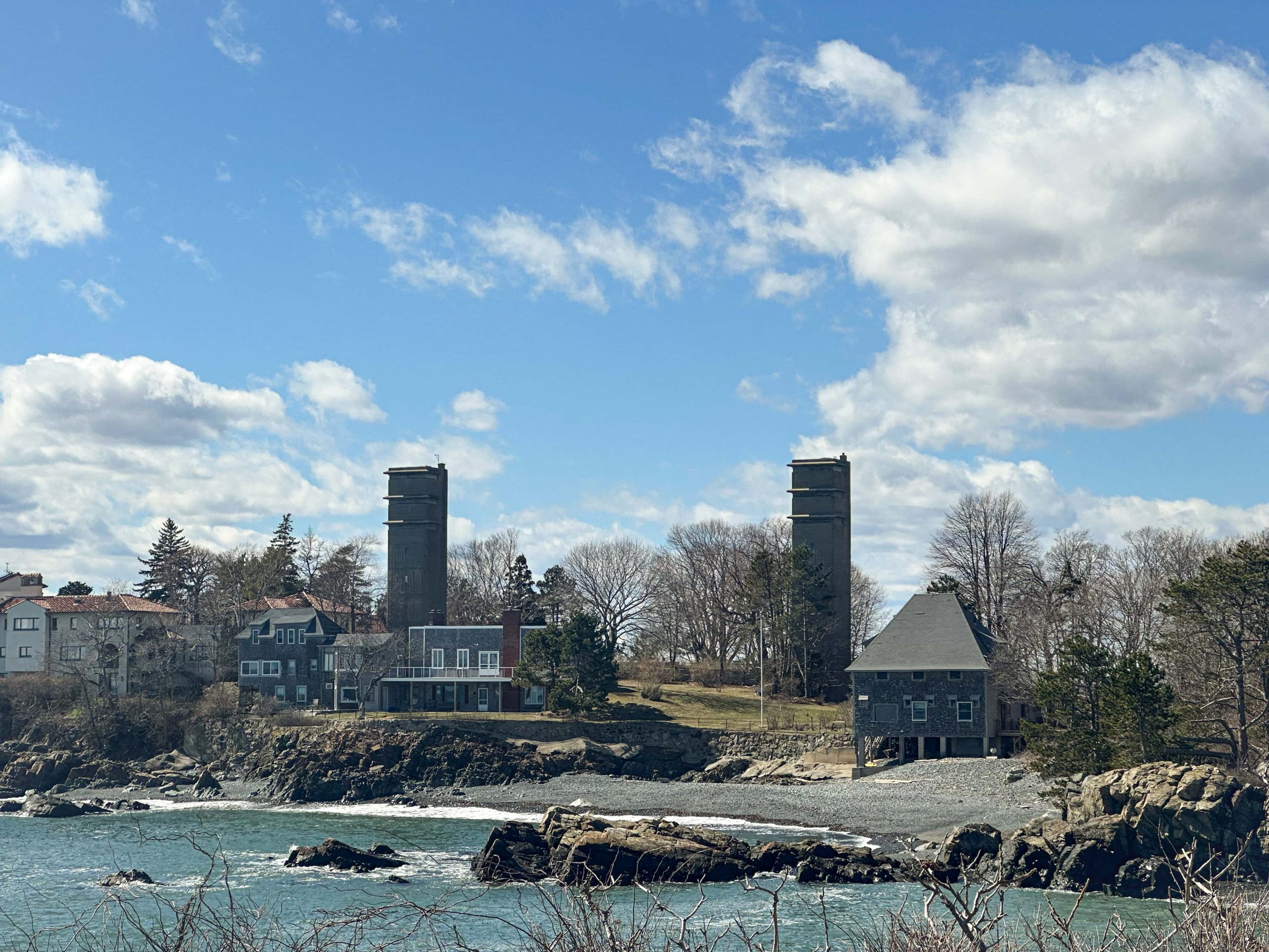
Today, Nahant East Point Fire Control Towers 131-1A and 131-2A are located right next to each other on Swallow Cave Road. They stand just about 200 feet apart and are currently located on private property. That said, visitors can still admire them from the road. Fire Control Tower 131-4A is also located on private property and it can be seen from Nahant Road.
Fire Towers 131-1A and 131-2A
The fire control towers were built from 1943-1944. The twin fire control towers, known officially as 131-1A and 131-2A were built on the southern side of the peninsula along Swallow Cave Road. They were built on land which was previously the Lowell Estate until the government acquired it. Both of these concrete towers were built to stand a whopping 8 stories high. They feature three levels of observation positions at the highest stories. Lookouts stationed at the towers had sweeping views out towards Boston Harbor, Massachusetts Bay, and the Atlantic Ocean. If any enemy was spotted by a lookout, the two towers could notify the nearby coastal gun batteries.
Each lookout position was assigned a different task. The upper station in Site 1A reported to Battery 206 at East Point, the middle station reported to Battery 105 at Fort Dawes on Deer Island, and the lower station was a Group 3 observation post. The upper station was equipped with a Depression Position Finder and the middle and lower stations had azimuth instruments. Each station was staffed with a crew of six men.
The upper station of Site 2A reported to Battery 104 at East Point, the middle station reported to Battery Gardner at Fort Ruckman, and the lower station was the commander’s station for Battery 206 at East Point. All of the stations at Site 2A were equipped with an azimuth instrument and had a crew of six.
The towers were abandoned after WW2 and eventually sold. Today, both of these towers are now located on private property and are not open to the public. It seems like they have been blocked off and not used by the current owners.

Fire Tower 131-4A
Fire Tower 131-4A is located north of the twin towers and just steps from the iconic Nahant Forty Steps. This tower sits high up on a bluff next to the Mifflin Estate House and was part of the East Point Military Reservation during World War 2. Unlike the twin towers, which were pretty standard, Site 131-4A actually had a bit more going on. This tower featured a Radar Shelter on top of it which was about 14 feet tall and disguised to look like a water tower. Inside the shelter was an SCR-296A radar. This was a short-range Surface Craft Detection Radar Set. Essentially, it would receive its target assignments from the harbor defense control station and then track the questionable watercraft. If one appeared to be dangerous, the crew stationed at 131-4A could notify nearby gun batteries to take aim.
Inside the tower, there were many different tools to boost the harbor defenses. The tower stood 6 stories tall and the four highest stories were developed for use. The third floor featured no windows but was used as a command post for the G-4 Command. This command was in control of five anti-motor torpedo boat 90mm batteries and four 3-inch gun batteries. The fourth floor was equipped with a Depression Position Finder to provide intel to the G-4 Command. The fifth floor was equipped with a spotting scope to provide intel to Battery Jewell on Outer Brewster Island. The sixth floor was home to the base end station Depression Position Finder for Battery Long on Fort Duvall in Hull, Massachusetts.
Following World War 2, the control tower was decommissioned and the radar shelter was removed. The tower, adjacent home, and the surrounding land were eventually sold to a private owner. Unlike the owners of the twin towers, the owner of Fire Tower 131-4A embraced having the tower as part of the property. The owners designed to totally renovate and repurpose the tower. Floors and walls were redone, electrical was re-wired, baseboard heat was added, and a bathroom was built on the third floor. It is believed that the current owners have small sleeping quarters on one floor, a recreational space on another, and hobby areas too.
Location Directions:


